Thursday, May 12, 2016

Robert Lewis Elgin, Land Surveyor


St. James Cemetery, St. James, Phelps County, Missouri, USA
Latitude: N 37°59'17.5", Longitude: W 091°36'51.8" (NAD 1983)

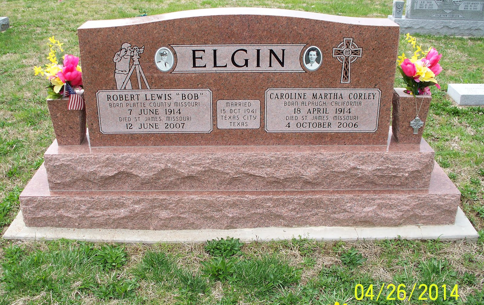
Robert Lewis "Bob" Elgin
Born: 07 June 1914 in Platte County, Missouri, USA
Died: 12 June 2007 at St. James, Phelps County, Missouri, USA

Bachelor of Science degree in Civil Engineering, 1937
Missouri School of Mines, Rolla, Missouri, USA

Missouri Professional Land Surveyor #890
Missouri Professional Engineer #3602


----------------------------
courtesy of Steven E. Weible

Monday, May 2, 2016

Odd Lots in Township 34 North, Range 6 West, Section 18, Missouri

Here is another interesting example of odd lots in the United States Public Land Survey System in Missouri:
image courtesy of the Missouri State Land Survey

This image comes from the "new" General Land Office (GLO) township plat for Township 34 North, Range 6 West of the Fifth Principal Meridian in Missouri.

It is dated November 30, 1861
image courtesy of the Missouri State Land Survey

and is signed by William Cuddy, Surveyor General for Missouri and Illinois
image courtesy of the Missouri State Land Survey

The oddity in this example is found in the southwest quarter of Section 18, where we see that the quarter section has been quartered into aliquot parts.  The "normal" procedure for the western tier of sections is to form as many lots of regular size as possible with the remainder being fractional, as was done in the northwest quarter of Section 18 and the west half of Section 19.  So, why would the northwest quarter of Section 18 be protracted "normally," while the southwest quarter is protracted differently?  Let's investigate further.

If we look for an "old" General Land Office township plat for Township 34 North, Range 6 West, we find the following:
image courtesy of the Missouri State Land Survey

This township plat is dated January 1, 1822
image courtesy of the Missouri State Land Survey

and is signed by Elisha Sims for William H. Ashley, the contracted deputy surveyor
image courtesy of the Missouri State Land Survey

Looking at this "old" township plat, we notice the red letter "S" in the southeast quarter of the southwest quarter of Section 18.  Looking in the margin of the "old" plat, we find the following explanation:
image courtesy of the Missouri State Land Survey

From this explanation we learn that the northern and western tier of sections were protracted in the Surveyor General's office on September 27, 1847 to accommodate the Act of Congress of April 5, 1832, which permitted the sale of quarter-quarter sections as the smallest unit of sale. We also learn that the southwest quarter of Section 18 was protracted to conform to a previous sale, indicated by the red letter "S" that we see in the southeast quarter of the southwest quarter of Section 18.

To find out more about the sequence of sales in the west half of Section 18, we can search for patent information at the United States Department of the Interior, Bureau of Land Management website, www.glorecords.blm.gov.  The results are as follows:

Location       Acres   Patentee            Issue Date
------------------------------------------------------
SE 1/4 SW 1/4   39.10  John Smith          1848 Mar 01
NE 1/4 SW 1/4   39.10  John Smith          1849 Apr 10
W 1/2 SW 1/4    78.20  Christopher Howell  1856 Sep 01
NW 1/4         157.19  William Hewes       1860 Aug 01

From this information we see that the patent for the southeast quarter of the southwest quarter was issued on March 1, 1848.  This date is after the protraction date of September 27, 1847, but probably represents the delay between the application for a patent and the issuance of the patent.

So, from the facts that we have gathered here we can come to the following conclusion as to why this oddity occurred:

- Lands in Township 34 North, Range 6 West of the Fifth Principal Meridian became available for sale.

- The Act of Congress of April 5, 1832 permitted the sale of land in quarter-quarter sections.

- The western tier of sections in this township had not been protracted into units smaller than the quarter section until September 27, 1847. (This had not been mentioned previously, but an examination of the 1822 township plat shows this to be so.)

- John Smith purchased a tract of land of a size permitted by the Act of April 5, 1832 with reference to a plat that had not yet been protracted into units that small.

- Since the plat had not yet been protracted, the land office official apparently made the assumption that the tract would be determined by aliquot part and made the sale accordingly.

- When the plat was later protracted into lots by a clerk in the Surveyor General's office, the previous sale had to be honored and not changed, even though it did not conform to the norm.


----------------------------------------
original composition by Steven E. Weible