This article has been modified. See Chapter 12 of "It Was Not Quick and It Was Not Simple: The Saga of Private Land Claims in Missouri". (Go to book now.)
Unlike the Spanish, however, the United States government was jealous for its newly acquired land and wanted to restrain new settlement until the land was ready to sell. Section 14 of the Act of March 26, 1804, chapter 38, An Act erecting Louisiana into two territories, and providing for the temporary government thereof (U. S. Statutes at Large, Vol. 2, pg 283), made it unlawful for any person to attempt a new settlement, to designate boundaries or to make a boundary survey of the lands of the United States within the limits of the former Province of Louisiana. Violators could be removed from the public lands by military force, fined up to one thousand dollars and imprisoned for up to twelve months.
President Thomas Jefferson emphasized to the Secretary of War the necessity of preventing squatters from settling on the public lands. The Secretary of War then gave instructions to the District Commandants to prohibit unauthorized settlements. When unauthorized settlements were discovered, any fixed improvements on the land were to be destroyed (Territorial Papers, Vol. 13, pg 19, 53, 54).
New settlers continued to come, however, and where else could they settle but on the public lands? It became difficult for the Commandants to distinguish unauthorized settlers from those having some kind of claim under the Spanish government (Territorial Papers, Vol. 13, pg 82). Some, who had made a settlement after the United States had taken possession of Upper Louisiana in March 1804, filed notice with the recorder of land titles, claiming a settlement right. For example, Francis Clark claimed 250 arpents of land on a branch of the St. Francis River based on a settlement and cultivation made in 1804 (ASP:PL Vol. 2, pg 550). George Horn claimed 300 arpents based upon permission to settle given by Captain Amos Stoddard in 1804 (ASPL:PL Vol. 2, pg 443). Jonathan Vineyard came from Georgia and claimed 500 arpents of land that he had settled in September 1804 (ASP:PL Vol. 2, pg 469).
The Act of March 3, 1807, chapter 46, An Act to prevent settlements being made on lands ceded to the United States, until authorized by law (U. S. Statutes at Large, Vol. 2, pg 445), stated that anyone attempting to make a settlement, designate boundaries or conduct a boundary survey on the public lands after the passage of the act, forfeited any right, title or claim to the land. Anyone who had settled without authorization on the public lands before the passage of this act was to be given three months notice before removal was to be enforced. To avoid removal the settler could apply for permission at any time before January 1, 1808 to continue to occupy up to 320 acres of public land as a tenant at will. Applying for permission, however, required a relinquishment of any claim to the land.
In 1809 President Jefferson reiterated his view that unauthorized settlements should be rigorously prohibited (Territorial Papers, Vol. 14, pg 248). Enforcement, however, remained problematic.
The Act of February 5, 1813, chapter 20, An Act giving the right of pre-emption in the purchase of lands to certain settlers in the Illinois territory (U. S. Statutes at Large, Vol. 2, pg 797), allowed settlers in the Territory of Illinois a preference in the purchase of the land that they had actually and continuously inhabited and cultivated as long as the land was not claimed by anyone else. The purchase preference would be at private sale as opposed to public sale and the tract would be limited to one quarter section per individual purchaser. The person claiming the preference had to deliver a written notice to the register of the land office at least two weeks before the public sales.
Section five of the Act of April 12, 1814, chapter 52, An Act for the final adjustment of land titles in the State of Louisiana and territory of Missouri (U. S. Statutes at Large, Vol. 3, pg 121), extended the purchase preference to the Territory of Missouri under the same restrictions, conditions, provisions and regulations as approved for the Territory of Illinois.
Settlements on the public lands continued, now with the hope of a preference in the purchase of the land (Territorial Papers, Vol. 15, pg 34). The United States government continued to oppose these settlements, however, and President James Madison issued a proclamation on December 12, 1815, ordering that all unlawful occupants should be removed (President Papers, Vol. 2, pg 557). The Secretary of War declared to Governor William Clark that “the premature occupancy of the public lands can be viewed only as an invasion of the sovereign rights of the United States, and must be repressed by the most prompt and energetic measures” (Territorial Papers, Vol. 15, pg 113).
The General Assembly of the Territory of Missouri responded in January 1816, protesting the President’s order and requesting a suspension until the public lands could be surveyed and offered for sale. They felt that such a drastic order deeply affected “the Interest and Welfare of a considerable portion of the Inhabitants of this Territory by taking from them their dwellings which atho’ they do not hold under the sanction of Law they had reason to believe from the indulgence which has been almost uniformly given by Congress not only by their [acquiescence] in such settlements but by extending to them the right of pre’emption they would be permitted quietly to occupy until the public Lands should be surveyed and offered for sale” (Territorial Papers, Vol. 15, pg 108). And, of course, enforcement was still problematic. Alexander McNair, Marshall of the Missouri Territory, in writing to Josiah Meigs, Commissioner of the General Land Office, on January 27, 1816, commented that “five Militia men of this Territory would not march against the intruders on public lands” (Territorial Papers, Vol. 15, pg 110, 111).
The United States government relented somewhat with the Act of March 25, 1816, chapter 35, An Act relating to settlers on the lands of the United States (U. S. Statutes at Large, Vol. 3, pg 260). This act allowed those who had settled on the public lands before February 1, 1816 to apply for permission before September 1, 1816 to continue to occupy up to 320 acres of public land as a tenant at will. The act would remain in force for one year.
The Act of February 17, 1815, An Act for the relief of the inhabitants of the late county of New Madrid, in the Missouri Territory, who suffered by earthquakes (U. S. Statutes at Large, Vol. 3, pg 211), brought a new threat to those hoping for a preference in the purchase of the land that they occupied. This act allowed the New Madrid claimants to locate a tract of land “on any of the public lands of the said territory, the sale of which is authorized by law” to replace their previously confirmed claims. Since those eligible for a preference of purchase could not designate their preemption claim until the public lands were surveyed, a land office was opened and the land made available for sale, it was possible for the New Madrid claimants to locate a claim on public land that was already occupied and improved (Territorial Papers, Vol. 15, pg 238). A New Madrid claim was not certain to prevail, however, since the right of preemption was authorized before the relief to those who suffered from the earthquakes (Territorial Papers, Vol. 15, pg 244; ASP:PL Vol. 4, pg 872).
By 1817 those eligible for a purchase preference were becoming very anxious. The register of the land office at St. Louis was daily receiving requests to enter preemption claims. No preemption claims could yet be accepted, though, because the register did not yet have the township plats on which to identify the preemption claims. The surveys had not yet been completed and land sales had not yet been authorized (Territorial Papers, Vol. 15, pg 282).
The first public land sales in the Territory of Missouri were authorized by the President in 1818 (Territorial Papers, Vol. 15, pg 385). The Act of February 17, 1818, chapter 12, An Act making provision for the establishment of additional land offices in the territory of Missouri (U. S. Statutes at Large, Vol. 3, pg 406), established additional land offices and defined the land district that each office would cover. New land offices were to be established at Franklin in the county of Howard, at a convenient location in the county of Arkansas (for lands located between the Base Line and the north boundary of the State of Louisiana), at the seat of justice in the county of Lawrence (for lands located between the Base Line and the north line of Township 15 North) and at Jackson in the county of Cape Girardeau. The first land office had already been established at St. Louis (Act of March 3, 1811, chapter 46, U. S. Statutes at Large, Vol. 2, pg 662).
In July 1818, Samuel Hammond, the receiver of public moneys at the land office in St. Louis, reported to Josiah Meigs that he and the register, Alexander McNair, had received the preemption claims for the first thirty townships authorized for sale. Most of the claims were clearly within the provisions of the law and there were only a few conflicting claims. There were some issues, however, as some claims turned out to be located in Section 16, which was reserved for the support of schools, and some were located in private claims that had not been confirmed (Territorial Papers, Vol. 15, pg 420).
As the land sales approached and the preemption claims were being considered, questions arose as to what constituted “inhabitation” and “cultivation” so as to qualify for the preference of purchase (Territorial Papers, Vol. 15, pg 423, 429). How much inhabitation and cultivation were required to qualify for the preference? Was a cabin and a garden patch enough? At what point should the inhabitation and cultivation have been established before a preference could be granted? Did it have to commence before April 12, 1814, when the right of preemption was extended to the Territory of Missouri? If a settler was industrious and extended his improvements into what turned out to be more than one quarter section, could he claim a preference for the full extent of his improvements?
To add to the confusion, the Act of April 29, 1816, chapter 162, An Act concerning pre-emption rights given in the purchase of lands to certain settlers in the state of Louisiana, and in the territory of Missouri and Illinois (U. S. Statutes at Large, Vol. 3, pg 330), allowed anyone who qualified for a preference of purchase that had settled on a fractional section or fractional quarter section of less than 160 acres to “have the privilege of purchasing one or more adjoining fractional quarter sections, or the adjoining quarter section, including their improvements, or the fraction improved by them, at their option.” The Act also provided for an adjustment when two qualifying settlers had settled on the same quarter section or fractional quarter section of land, so that each settler would secure his improvements. The Act concluded by stating that “where the improvement of such person shall be upon two or more quarter sections, such person shall be entitled to purchase the quarter sections upon which his improvement shall be.”
There was considerable correspondence between the registers and receivers in the land offices, the Commissioner of the General Land Office and the Secretary of the Treasury, trying to work through the confusion, which was compounded by delays in delivery of the mail (Territorial Papers, Vol. 15, pg 432, 440, 460, 463, 470, 473, 484, 486, 499, 502, 509, 511, 522, 524, 525, 528, 536, 542, 550, 599, 602, 608, 647, 659, 662, 702). Added to that confusion were protests and demands sent to Congress by the General Assembly of the Territory of Missouri (Territorial Papers, Vol. 15, pg 489, 495, 502, 594, 656).
The Act of March 3, 1819, chapter 86, An Act explanatory of the act entitled “An act for the final adjustment of land titles in the state of Louisiana and territory of Missouri” (U. S. Statutes at Large, Vol. 3, pg 517), cleared up some points of confusion. There had been some uncertainty as to whether or not the right of preemption applied to the county of Howard, since it was unclear when it had officially ceased to be Indian territory and had become an organized part of the territory of Missouri (Territorial Papers, Vol. 15, pg 440, 460, 463). Section one of this act explicitly extended the right of preemption to the county of Howard as it had been established by the territorial legislature on January 23, 1816. Section three of the act allowed the right of preemption to those that had settled and improved land that ended up being in Section 16 after the surveys were completed. Replacement lands for the support of schools would be selected in the same township.
As in other instances where relief was provided by Congress to those that qualified, there were those who tried to take advantage of the situation to gain a preference, while doing as little as possible to justify it. Ultimately, it was up to the register and receiver of each land office to evaluate the preemption claims presented to them and to extend the relief intended by Congress (Territorial Papers, Vol. 15, pg 599, 602, 608, 662). Charles Carroll, register, and T. A. Smith, receiver for the land office at Franklin in Howard County, explained their proceedings in a letter, dated November 6, 1820, by saying, “We considered the sectional line a Barrier in all cases but one embraced in the first section of the Law of 29th April 1816 & then only permitted them to cross the sectional line to give them the quantity contemplated by Law. A different construction would have allowed an artful & cunning man to have spread over a Township & once pass the barrier & there is no limit. Where two Persons were Settled on one quarter or fractional quarter we gave to each an adjoining qr & half of the quarter they were settled on & where more were settled we divided the section between them. We certainly required Cultivation for the support of a family & did not consider shelots which are indigenous to the country, or the marking of Trees, or planting a few peach Stones or sowing a few appleseeds or putting out a few Scions evidences of cultivation or the Encampment on the ground for a night “actual Inhabitation”, where proof was offered of growing any Crop for the Sustenance of man, even “Turnips”, it mattered not how they were put in whether with the plough, a cane or the hand it was deemed sufficient & the Preemption was granted” (Territorial Papers, Vol. 15, pg 662).
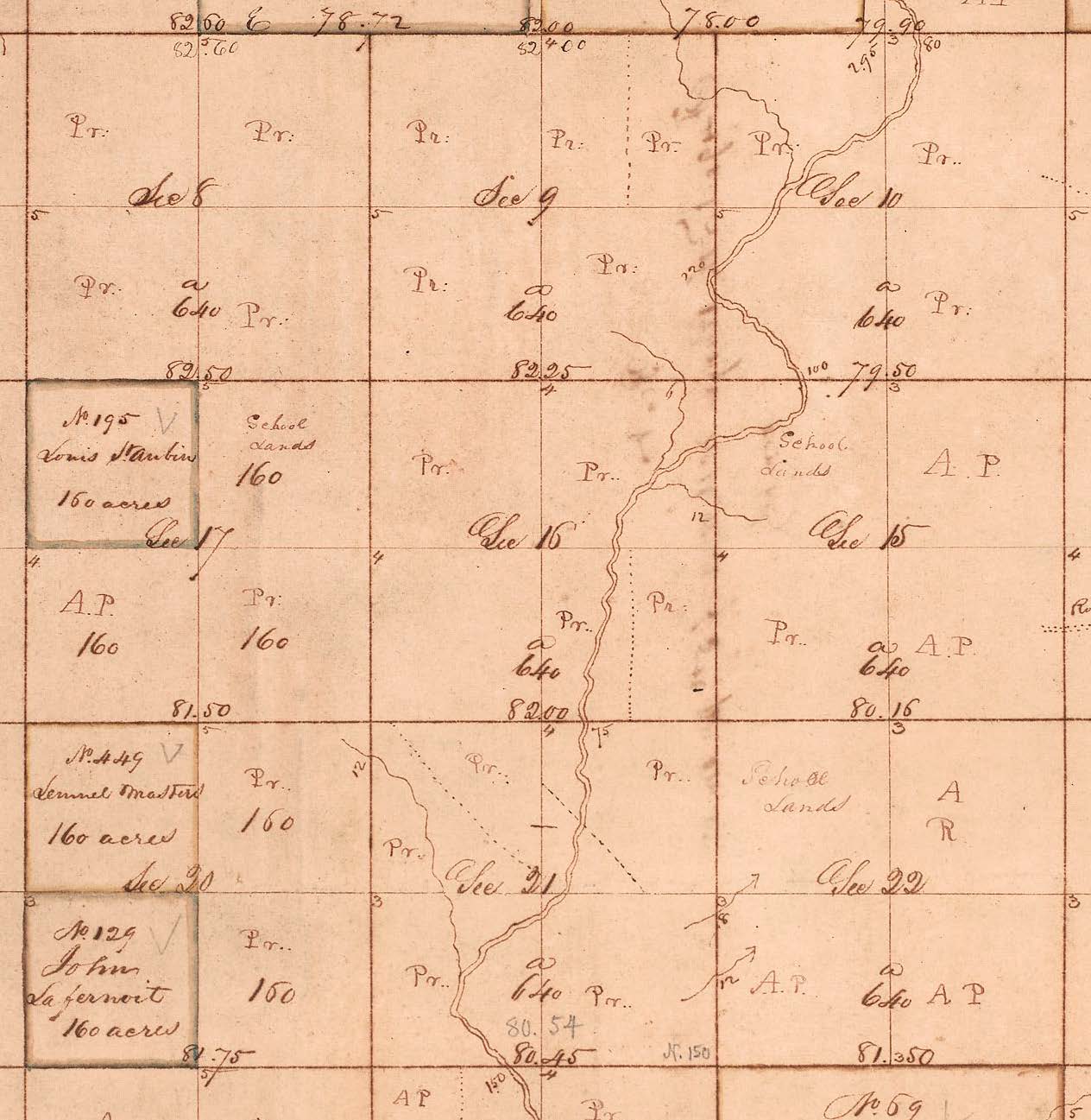
This extract from the marked-up 1816 township plat (the old plat) for Township 49 North, Range 16 West shows tracts of land marked "Pr." to indicate claims by preemption. Notice that the northeast quarter of Section 9, the southeast quarter of Section 16 and the northwest quarter of Section 21 were divided between two settlers. The northwest quarter of Section 21 was patented as "the northeast corner" (100.5 acres) and the "south part" (59.5 acres). Also notice that three quarters of Section 16 were claimed by preemption and replacement lands for the support of schools were designated in Sections 15, 17 and 22. New Madrid claims were located in Sections 17 and 20.
According to Section 8 of the Act of May 10, 1800, chapter 55 (2 Stat 73) the register of the land office was to place a letter "A" on the township plat when application was made and 1/20 of the purchase price was paid. A letter "P" was placed on the plat when 1/4 of the purchase price had been paid. A letter "R" was placed on the plat when the land reverted to the United States, because of a failure to pay 1/4 of the purchase price within three months after the date of application. See also Territorial Papers, Vol. 15, pg 608.
SOURCES
A Compilation of the Messages and Papers of the Presidents
American State Papers: Public Lands (ASP:PL)
American State Papers: Miscellaneous (ASP:MISC)
Stoddard, Major Amos, Sketches, Historical and Descriptive, of Louisiana, 1812
The Territorial Papers of the United States, compiled by Clarence Edwin Carter, 1948
U. S. Statutes at Large
----------------------------------------
original composition by Steven E. Weible