The following is
the text of the contract document between William Rector, Principal Deputy Surveyor of the
Territory of Missouri, and Prospect K. Robbins, U. S. Deputy
Surveyor, for the survey of the Fifth Principal Meridian.
=========================================================================
Articles of agreement had, made and concluded upon the Ninth day of October in the year of our Lord, one thousand eight hundred and fifteen. Between William Rector principal deputy Surveyor of the Territory of Missouri, acting under the direction of the Surveyor General of the United States, and in behalf of the United States, of the one part and Prospect K. Robbins of the other part. Witnesseth that the said Prospect K. Robbins for and in consideration of the conditions, terms, provisions and covenants herein after expressed and according to the true intent and meaning thereof, doth hereby covenant and agree with the said William Rector, in his capacity aforesaid, that he the said Prospect K. Robbins will faithfully and accurately do and perform the following Surveying in the Missouri Territory, agreeably to the Land of the United States and the instructions given him by the said William Rector, which are hereunto annexed. That is to say, he the said Prospect K. Robbins, will survey as aforesaid a line due North agreeably to the true meridian, from the confluence of the Arkansas and Mississippi rivers to the Southerly bank of the Missouri river, which said line is known and termed on the annexed plat - The fifth principal meridian, and the said P. K. Robbins, will in case it should become necessary, as mentioned in the annexed instructions, Survey a base line due West, agreeably to the true meridian from the mouth of the St. Francis river, until it shall intersect the said fifth principal meridian. And the said Prospect K. Robbins covenants and agrees that if in the course of performing the Surveys of the said Meridian line any corner shall fall (whether of Townships, sections or quarter sections) within any prairie, where bearing trees within a reasonable distance from such corner can not be found, then and in that case, he will erect a mound of earth or sod as the marks of such corners and will finally place therein posts of the usual size. The mounds to be at least two feet six inches high and two feet six inches diameter at the Base. And the said Prospect K. Robbins further covenants and agrees that he will make out three neat and accurate plats of the aforesaid line or lines which shall be laid down by a scale of Five miles or four hundred chains to an inch & that he will complete the Survey and plats aforesaid and make return thereof within three months from the date thereof on penalty of forfeiture, and paying to the United States the sum of Two thousand dollars if default be made in any of the foregoing conditions. And the said William Rector covenants and agrees that on the completion of the work in manner aforesaid, there shall be paid to the said Prospect K. Robbins on account of the United States, as a full compensation for the expense of surveying and making the plats aforesaid, Three dollars per mile for every mile and part of a mile actually run and marked, random lines and offsets not included, provided no member of Congress have any part in this contract. In testimony whereof the parties to this indenture have interchangably set their hands and seals the day and year aforesaid.
{signed} William Rector, Principal Deputy Surveyor of the Territory of Missouri
{signed} Prospect. K. Robbins, Deputy Surveyor, Territory of Missouri
Signed, sealed, and delivered in presence of us
D. Delawney
William L. May
Oct. 9th 1815=========================================================================
Source Reference: Missouri Contracts 1815-1843, pages
1-2,
Missouri Department of Natural
Resources microfiche location: 720/3286B3
-------------------------------
Transcribed by Steven E. Weible
Thursday, January 10, 2013
Friday, December 7, 2012
The Public Relations Aspect of Land Surveying
Note: The following account is factual in every regard except that all names have been generalized.
The Real Estate Manager of the Agency for whom I work requested that our crew mark a property boundary line so that the Agency planners could determine its impact on plans for development. The Agency's deed called for an aliquot part line that had been monumented a few years ago, so the task did not appear to be one that would be too difficult to accomplish.
On Thursday, September 28, 2006, we arrived on site and began recovering the previously monumented corners that defined the line that we needed to mark. As we looked for and recovered the quarter corner monument between Sections 5 & 8 at the east end of our project on the east side of the state highway, we immediately encountered Mr. Friendly, the landowner on that side of the highway. He told us that he was from an urban area and had acquired the land he owned for recreation. He was very interested in talking about the location of the section lines and how they related to his own property boundaries. He even had with him survey information that he had gotten from the State Land Survey Repository. As long as we were willing to talk with him, he was eager to get as much free surveying information as he could.
As we talked, Mr. Friendly related to me how he had talked to the Property Superintendent one day when she came by to look at the location directly across from his driveway. He stated that she had told him she thought the Agency owned that area all the way to the county road to the north and that there were plans to build a new Superintendent's residence there. Before that could be done, he stated, an old frame building on a stone foundation had to be examined to determine if it had any historical value or anything like that. If not, the plans were to tear it down.
After his conversation with the Property Superintendent, Mr. Friendly then had a conversation with an unnamed person who indicated that if the Agency tore down the old building, it would be a very expensive building. This was the first indication to me that we may be dealing with a boundary dispute instead of merely an inquiry as to where the boundary was located. Before we even made any measurements, I could see from the location of the quarter corner monument that the section line would run through the middle of the old building.
We proceeded with traverse work that same day and continued on Tuesday, October 3, 2006, and Wednesday, October 4, 2006. On Wednesday afternoon as we completed the traverse work and were loading up our equipment in the parking lot, a white, extended cab Chevy pickup turned in to the parking lot and came directly to us (ignoring the one-way signage). A man jumped out of the truck, muttering something under his breath, and very confrontationally demanded to know what corners we were using to locate the property boundary. I proceeded to tell him that we had used the monumented quarter corner between Sections 5 & 8 and the monumented corner of sections 5, 6, 7 & 8. Before I could even finish, he stated that the corners were all wrong and that we were wrong and didn't know what we were doing. I asked if he had any documentation to support his assertion. Very quickly, he responded "Oh, yes" and reached in the passenger side of his pickup and pulled out a folded piece of slightly yellowed paper.
As he unfolded the large drawing, well worn with use, I could see that it was a tax map showing planimetrics without aerial photography. I had previously obtained a copy of this map and I knew that it did not accurately represent the relationship between the section line (between Sections 5 & 8) and the Subdivision lots along the county road to the north. This was understandable because the plat of the Subdivision lots does not show a tie to the section corners or lines, so the people in the Assessor's office would have no idea exactly where the lots were located in Section 5. Seeing this, I told the man that what he had was only a tax map and not a survey and that it could not be relied upon to determine the location of property boundaries. He then pulled out an 8.5" x 11" piece of paper that appeared to be a copy of part of a larger drawing. It looked like some kind of display plat for the Subdivision lots, having Block designations, but no lot numbers. It was, basically, a hand drafted copy of the tax map, having no dimensions. At the bottom of the paper was the name of a Surveying Company. In addition, someone had penciled in some distances for the tract that this man claimed to own. I presume these distances were scaled from the tax map; otherwise, I have no idea where they came from.
Having seen his documentation, I pulled out my own documentation and described to him from the documents the history of the corners I was using and showed him the surveys that had been conducted in accordance with state law that demonstrated that the tax map was not a reliable source for locating the property boundary. I also directed him to a statement appearing on the face of every tax map that reads as follows:
"THIS REAL PROPERTY OWNERSHIP MAP IS FOR TAX PURPOSES ONLY AND IT IS NOT INTENDED FOR REAL PROPERTY CONVEYANCES OR DESCRIPTIONS."
I gave the man one of my business cards and asked his name, which he indicated was Mr. Unhappy. He was not convinced by my response to his claim and insisted that it was not right and that he would fight it. He claimed that some old man had told him there was a pin in the middle of the state highway that was the property corner. I told Mr. Unhappy that we had a metal detector and that we could look for this pin, if he wanted to. So, we drove up to the old frame building on the stone foundation and probed with the metal detector the area that Mr. Unhappy indicated. We found nothing.
Mr. Unhappy still insisted that where we had cut line through on the south side of the building was not right. At that point I advised Mr. Unhappy that we had not yet marked the boundary line and that preliminary indications were that the line would run through the middle of the old building. Mr. Unhappy continued to insist that this wasn't right. I asked again about the copy from the Surveying Company and he emphatically affirmed that it had come directly from the Surveying Company. I, then, told him that he should contact the Surveying Company to see what they had to say about it.
I told him that the difference in our arguments was that I was basing mine on documented corners and surveys performed in accordance with the law and he was basing his argument on a tax map. By this time, Mr. Unhappy was becoming somewhat distressed. There wasn't anything else that I could tell him that would be helpful or convince him to change his mind. When he left, he indicated that he was going to get his measuring tape and measure off the dimensions that were penciled on the Surveying Company drawing.
Some other information that was revealed in our conversation with Mr. Unhappy are as follows:
- Mr. Unhappy had a high power rifle with a scope in the floor board of his truck, like it had recently been in use or was ready to be put to use.
- Mr. Unhappy indicated that he lived back up the county road that ran through the Subdivision lots and that he owned property back there.
- He also indicated that the horseback riders interrupted his hunting.
- He advised us to carry a gun (I'm not sure if that was intended as a threat or not).
- A little later he advised us to carry a gun because of wild hogs.
- He indicated that he (or one of his companions) had killed a 300 pound wild hog "last Saturday" (we were talking to him on October 4th, so I guess the hog would have been killed on September 30th).
- He indicated a desire to fix up and use the old frame building on the stone foundation. I'm not sure why he is so interested in the old building. It is in bad shape with the front "porch" falling in. It has two millstones in the stone foundation, though, that are rather interesting.
The next day, Thursday, October 5, 2006, we returned to perform some GPS observations to ensure accuracy and to tie to the State Plane Coordinate System. We encountered Mr. Friendly again while we were performing these observations. As before, he was very interested in talking about surveying, specifically, how it related to the location of his own boundary lines. He asked me if I could survey his property on the side, to which I indicated that I could not. He then indicated that he had talked to Mr. Unhappy that morning. Mr. Unhappy had stopped to take some pictures of the old frame building on the stone foundation. Mr. Friendly indicated that Mr. Unhappy had a strong desire to keep the old building. Mr. Friendly also related to me how Mr. Unhappy had apparently talked to someone from the Agency (after talking to us) who had brought up the possibility of a land trade.
We returned to the site to mark the boundary on October 12, 2006. While there, we observed that some clearing had been done north of the old frame building on the stone foundation. It was not evident who had done the clearing or for what purpose.
On October 17, 2006 I went to the County Courthouse to search for answers to the questions that had by now developed. According to the Assessor's records, Mr. Unhappy owned four Subdivision lots, which he acquired in April 2004, October 2005 and November 2005. Each of these lots is in the neighborhood of about 1/3 acre in size. I searched the indexes from 1978 to the present and found no conveyances to Mr. Unhappy other than the four Subdivision lots. According to the Assessor's records, the tract of land with the old frame building on the stone foundation that lies in Section 5, belonged to a Real Estate Service located in an urban area.
We returned to the site in November 2006 to collect additional information needed to facilitate a land trade proposal. In the mean time, the Real Estate Manager contacted Mr. Unhappy to discuss the possibility of a land trade to resolve the situation. The Agency required some proof of ownership from Mr. Unhappy, however, since the county records showed ownership of the adjoining tract in someone else. Mr. Unhappy told the Real Estate Manager that he had the deed in hand, but that he had not at that time recorded it yet. A copy of the document obtained after it was recorded revealed that it was dated September 2, 2006, but that it was not signed and notarized until October 6, 2006, which was 2 days after our encounter in the field.
Based on the information that we collected, I provided the Real Estate Manager with three options for a proposed land trade to put Mr. Unhappy in possession of an entire building. Agency Management selected the preferred option and the Real Estate Manager presented the proposal to Mr. Unhappy for consideration.
We were again on site on Tuesday, December 19 and Wednesday, December 20, 2006 for some other survey work. We did not see Mr. Unhappy at all on Tuesday, December 19, but we did see another surveyor working at the site. Mr. Unhappy had told the surveyor that he was going to get 100 guineas and some pigs so that they would be both noisy and stinky.
On Wednesday, December 20, Mr. Unhappy stopped to talk at us. He told me that we better move those "stakes" off of his property, etc. He said that we were putting a bend in the section line. He was obviously angry and said that he would tear down his half of the old building and leave the other half. He went on to tell me that he was going to get dead hogs and leave them lay on his property so that no one would want to come to the new development. He was on his way to a doctor's appointment, so he couldn't stay long. He didn't bring up the reputed testimony of "everyone", so I didn't have an opportunity to ask to talk to his witnesses. He again stated that I was wrong in my location of the property boundary and I again inquired how he arrived at that determination and he again referred to his "plot plan," which he stated was made by a surveyor, but he couldn't remember the name. I told him that if he had any credible information contrary to what I was working with that I would be interested in examining what he had, but he would have to support his claims with credible facts.
We prepared a boundary survey for a proposed boundary line adjustment in May 2007 and filed it with the County Recorder of Deeds. Before the swap of Quit Claim deeds could proceed, though, there were, apparently, some property tax issues related to the tract that Mr. Unhappy had acquired that needed to be addressed. For whatever reason, the proposal went no further and nothing more was heard from Mr. Unhappy.
----------------------------------------
Original composition by Steven E. Weible
The Real Estate Manager of the Agency for whom I work requested that our crew mark a property boundary line so that the Agency planners could determine its impact on plans for development. The Agency's deed called for an aliquot part line that had been monumented a few years ago, so the task did not appear to be one that would be too difficult to accomplish.
On Thursday, September 28, 2006, we arrived on site and began recovering the previously monumented corners that defined the line that we needed to mark. As we looked for and recovered the quarter corner monument between Sections 5 & 8 at the east end of our project on the east side of the state highway, we immediately encountered Mr. Friendly, the landowner on that side of the highway. He told us that he was from an urban area and had acquired the land he owned for recreation. He was very interested in talking about the location of the section lines and how they related to his own property boundaries. He even had with him survey information that he had gotten from the State Land Survey Repository. As long as we were willing to talk with him, he was eager to get as much free surveying information as he could.
As we talked, Mr. Friendly related to me how he had talked to the Property Superintendent one day when she came by to look at the location directly across from his driveway. He stated that she had told him she thought the Agency owned that area all the way to the county road to the north and that there were plans to build a new Superintendent's residence there. Before that could be done, he stated, an old frame building on a stone foundation had to be examined to determine if it had any historical value or anything like that. If not, the plans were to tear it down.
 |
| Old Frame Building on Stone Foundation |
After his conversation with the Property Superintendent, Mr. Friendly then had a conversation with an unnamed person who indicated that if the Agency tore down the old building, it would be a very expensive building. This was the first indication to me that we may be dealing with a boundary dispute instead of merely an inquiry as to where the boundary was located. Before we even made any measurements, I could see from the location of the quarter corner monument that the section line would run through the middle of the old building.
We proceeded with traverse work that same day and continued on Tuesday, October 3, 2006, and Wednesday, October 4, 2006. On Wednesday afternoon as we completed the traverse work and were loading up our equipment in the parking lot, a white, extended cab Chevy pickup turned in to the parking lot and came directly to us (ignoring the one-way signage). A man jumped out of the truck, muttering something under his breath, and very confrontationally demanded to know what corners we were using to locate the property boundary. I proceeded to tell him that we had used the monumented quarter corner between Sections 5 & 8 and the monumented corner of sections 5, 6, 7 & 8. Before I could even finish, he stated that the corners were all wrong and that we were wrong and didn't know what we were doing. I asked if he had any documentation to support his assertion. Very quickly, he responded "Oh, yes" and reached in the passenger side of his pickup and pulled out a folded piece of slightly yellowed paper.
As he unfolded the large drawing, well worn with use, I could see that it was a tax map showing planimetrics without aerial photography. I had previously obtained a copy of this map and I knew that it did not accurately represent the relationship between the section line (between Sections 5 & 8) and the Subdivision lots along the county road to the north. This was understandable because the plat of the Subdivision lots does not show a tie to the section corners or lines, so the people in the Assessor's office would have no idea exactly where the lots were located in Section 5. Seeing this, I told the man that what he had was only a tax map and not a survey and that it could not be relied upon to determine the location of property boundaries. He then pulled out an 8.5" x 11" piece of paper that appeared to be a copy of part of a larger drawing. It looked like some kind of display plat for the Subdivision lots, having Block designations, but no lot numbers. It was, basically, a hand drafted copy of the tax map, having no dimensions. At the bottom of the paper was the name of a Surveying Company. In addition, someone had penciled in some distances for the tract that this man claimed to own. I presume these distances were scaled from the tax map; otherwise, I have no idea where they came from.
Having seen his documentation, I pulled out my own documentation and described to him from the documents the history of the corners I was using and showed him the surveys that had been conducted in accordance with state law that demonstrated that the tax map was not a reliable source for locating the property boundary. I also directed him to a statement appearing on the face of every tax map that reads as follows:
"THIS REAL PROPERTY OWNERSHIP MAP IS FOR TAX PURPOSES ONLY AND IT IS NOT INTENDED FOR REAL PROPERTY CONVEYANCES OR DESCRIPTIONS."
I gave the man one of my business cards and asked his name, which he indicated was Mr. Unhappy. He was not convinced by my response to his claim and insisted that it was not right and that he would fight it. He claimed that some old man had told him there was a pin in the middle of the state highway that was the property corner. I told Mr. Unhappy that we had a metal detector and that we could look for this pin, if he wanted to. So, we drove up to the old frame building on the stone foundation and probed with the metal detector the area that Mr. Unhappy indicated. We found nothing.
Mr. Unhappy still insisted that where we had cut line through on the south side of the building was not right. At that point I advised Mr. Unhappy that we had not yet marked the boundary line and that preliminary indications were that the line would run through the middle of the old building. Mr. Unhappy continued to insist that this wasn't right. I asked again about the copy from the Surveying Company and he emphatically affirmed that it had come directly from the Surveying Company. I, then, told him that he should contact the Surveying Company to see what they had to say about it.
I told him that the difference in our arguments was that I was basing mine on documented corners and surveys performed in accordance with the law and he was basing his argument on a tax map. By this time, Mr. Unhappy was becoming somewhat distressed. There wasn't anything else that I could tell him that would be helpful or convince him to change his mind. When he left, he indicated that he was going to get his measuring tape and measure off the dimensions that were penciled on the Surveying Company drawing.
Some other information that was revealed in our conversation with Mr. Unhappy are as follows:
- Mr. Unhappy had a high power rifle with a scope in the floor board of his truck, like it had recently been in use or was ready to be put to use.
- Mr. Unhappy indicated that he lived back up the county road that ran through the Subdivision lots and that he owned property back there.
- He also indicated that the horseback riders interrupted his hunting.
- He advised us to carry a gun (I'm not sure if that was intended as a threat or not).
- A little later he advised us to carry a gun because of wild hogs.
- He indicated that he (or one of his companions) had killed a 300 pound wild hog "last Saturday" (we were talking to him on October 4th, so I guess the hog would have been killed on September 30th).
- He indicated a desire to fix up and use the old frame building on the stone foundation. I'm not sure why he is so interested in the old building. It is in bad shape with the front "porch" falling in. It has two millstones in the stone foundation, though, that are rather interesting.
The next day, Thursday, October 5, 2006, we returned to perform some GPS observations to ensure accuracy and to tie to the State Plane Coordinate System. We encountered Mr. Friendly again while we were performing these observations. As before, he was very interested in talking about surveying, specifically, how it related to the location of his own boundary lines. He asked me if I could survey his property on the side, to which I indicated that I could not. He then indicated that he had talked to Mr. Unhappy that morning. Mr. Unhappy had stopped to take some pictures of the old frame building on the stone foundation. Mr. Friendly indicated that Mr. Unhappy had a strong desire to keep the old building. Mr. Friendly also related to me how Mr. Unhappy had apparently talked to someone from the Agency (after talking to us) who had brought up the possibility of a land trade.
We returned to the site to mark the boundary on October 12, 2006. While there, we observed that some clearing had been done north of the old frame building on the stone foundation. It was not evident who had done the clearing or for what purpose.
On October 17, 2006 I went to the County Courthouse to search for answers to the questions that had by now developed. According to the Assessor's records, Mr. Unhappy owned four Subdivision lots, which he acquired in April 2004, October 2005 and November 2005. Each of these lots is in the neighborhood of about 1/3 acre in size. I searched the indexes from 1978 to the present and found no conveyances to Mr. Unhappy other than the four Subdivision lots. According to the Assessor's records, the tract of land with the old frame building on the stone foundation that lies in Section 5, belonged to a Real Estate Service located in an urban area.
We returned to the site in November 2006 to collect additional information needed to facilitate a land trade proposal. In the mean time, the Real Estate Manager contacted Mr. Unhappy to discuss the possibility of a land trade to resolve the situation. The Agency required some proof of ownership from Mr. Unhappy, however, since the county records showed ownership of the adjoining tract in someone else. Mr. Unhappy told the Real Estate Manager that he had the deed in hand, but that he had not at that time recorded it yet. A copy of the document obtained after it was recorded revealed that it was dated September 2, 2006, but that it was not signed and notarized until October 6, 2006, which was 2 days after our encounter in the field.
Based on the information that we collected, I provided the Real Estate Manager with three options for a proposed land trade to put Mr. Unhappy in possession of an entire building. Agency Management selected the preferred option and the Real Estate Manager presented the proposal to Mr. Unhappy for consideration.
We were again on site on Tuesday, December 19 and Wednesday, December 20, 2006 for some other survey work. We did not see Mr. Unhappy at all on Tuesday, December 19, but we did see another surveyor working at the site. Mr. Unhappy had told the surveyor that he was going to get 100 guineas and some pigs so that they would be both noisy and stinky.
On Wednesday, December 20, Mr. Unhappy stopped to talk at us. He told me that we better move those "stakes" off of his property, etc. He said that we were putting a bend in the section line. He was obviously angry and said that he would tear down his half of the old building and leave the other half. He went on to tell me that he was going to get dead hogs and leave them lay on his property so that no one would want to come to the new development. He was on his way to a doctor's appointment, so he couldn't stay long. He didn't bring up the reputed testimony of "everyone", so I didn't have an opportunity to ask to talk to his witnesses. He again stated that I was wrong in my location of the property boundary and I again inquired how he arrived at that determination and he again referred to his "plot plan," which he stated was made by a surveyor, but he couldn't remember the name. I told him that if he had any credible information contrary to what I was working with that I would be interested in examining what he had, but he would have to support his claims with credible facts.
We prepared a boundary survey for a proposed boundary line adjustment in May 2007 and filed it with the County Recorder of Deeds. Before the swap of Quit Claim deeds could proceed, though, there were, apparently, some property tax issues related to the tract that Mr. Unhappy had acquired that needed to be addressed. For whatever reason, the proposal went no further and nothing more was heard from Mr. Unhappy.
----------------------------------------
Original composition by Steven E. Weible
Saturday, November 17, 2012
French and English land measures formerly used in Missouri
Note: The following information was included in a report presented to the U. S. Senate in March 1824, concerning contracts for surveying the public lands in Illinois, Missouri and Arkansas from January 1, 1819 to April 1822.
Source reference: American State Papers, Public Lands, Volume 4, page 19, No. 423.
A comparative statement of the land measures of the United States,
and the French measures formerly used in the late province of Louisiana
Lineal measure
72 French feet = 77 English (U.S.) feet
6 French perches = 7 English (U.S.) poles = 1.75 chains
10 French perches = 1 lineal French Arpent
12 lineal French Arpents = 35 chains
Superficial measure (area)
288 Arpents = 245 acres
1 League square = 7056 Arpents = 6002.50 acres
Tuesday, November 13, 2012
Surveyor General Comments on Little Prairie, Missouri
A plat of the Village of Little Prairie as it existed in 1806 is found of record on pages 84 and 85 of Book E in the Office of the U. S. Recorder of land titles, and a copy of the same is on file in this office [i.e., the Surveyor General's office].
The survey of said village as directed to be made according to the provisions of the act of 13th June 1812 and 26 May 1824 was contracted for with Jos. C. Brown on the 26th April 1843. Instructions to that effect were issued to said Brown on the 7th May 1845. See letter book K p. 282.
Mr. Brown when he afterward returned the papers furnished him to that purpose, reported that no survey of the old village could be made, because the ground on which it was situated having been washed away by the Mississippi river. For a statement of which fact see his receipt filed with his account, being Voucher No. 1 of account current under appropriations for towns and villages, 1st quarter of 1846 and Record thereof in Book B of accounts p. 151.
See also the Commissioner’s letter of the 26th January 1847, book S, p. 3, and the Surveyor General’s answer of 17th February 1847, Book M, p. 83.
=======================================================================
Source Reference: Book of Reference, Vol. 33N, page 45,
Missouri Department of Natural Resources microfiche location: 720/2778A2
Monday, November 12, 2012
Joseph C. Brown's contract dated September 15, 1835
The following is the text of the contract document between Elias T. Langham, Surveyor of the Public Lands in Illinois and Missouri, and Joseph C. Brown, U. S. Deputy Surveyor, for the survey of town and village lots in Saint Louis, Missouri.
=========================================================================
Articles of Agreement had, made, and concluded, the fifteenth day of September one thousand eight hundred and thirty five, between Elias T. Langham Surveyor of the public lands in Illinois and Missouri, acting for and in behalf of the United States of the one part, and Joseph C. Brown of the County of Saint Louis, and State of Missouri of the other part, witnesseth: That the said Joseph C. Brown for and in consideration of the terms, provisions and covenants, herein after expressed and according to the true intent and meaning thereof, doth hereby covenant and agree, with the said Elias T. Langham in his capacity aforesaid, that he the said Joseph C. Brown will under his own personal and immediate superintendance and not by sub-contract, execute the following described surveying, situate in the County of St. Louis and State of Missouri, agreeably to the laws of the United States, and such instructions as may be given to him by the said Elias T. Langham, Viz: He will survey the Town and out lots of the Town (now City) of Saint Louis, and the lots of the common fields attached thereto, which have been confirmed by the laws of the United States and have not heretofore been surveyed, and he will also survey the out boundaries of the Town, and of the several common fields, either in separate parcels, or in one general survey, according as he may be instructed by the said Langham, and the said Joseph C. Brown further covenants and agrees that he will complete the aforesaid surveying and make returns to the office of the Surveyor of the lands of the United States in Illinois and Missouri within six months from the date hereof, his field notes and a separate plat of each lot and block, showing the proper connection in every case with the adjoining and adjacent lots and blocks. And the said Elias T. Langham covenants and agrees in his capacity aforesaid, that on the completion of the work in the manner aforesaid, there shall be paid to the said Joseph C. Brown as a full compensation for his own personal services and expenses, at the rate of six dollars per day, from the time he shall commence work, until the surveys and returns aforesaid are completed, and also, all other necessary expenses, provided the Surveys and returns shall be approved of by the Surveyor of the lands of the United States, in Illinois and Missouri. In witness whereof, the parties to this agreement, hereunto set their hands & seals in duplicate, signed at St. Louis in the State of Missouri, this fifteenth day of September 1835.
{signed} E. T. Langham (seal)
{signed} Jos C. Brown (seal)
Witness: William Milburn
=========================================================================
Source Reference: Missouri Contracts 1815-1843, pages 313-315,
Missouri Department of Natural Resources microfiche location: 720/3303A4
-------------------------------
Transcribed by Steven E. Weible
=========================================================================
Articles of Agreement had, made, and concluded, the fifteenth day of September one thousand eight hundred and thirty five, between Elias T. Langham Surveyor of the public lands in Illinois and Missouri, acting for and in behalf of the United States of the one part, and Joseph C. Brown of the County of Saint Louis, and State of Missouri of the other part, witnesseth: That the said Joseph C. Brown for and in consideration of the terms, provisions and covenants, herein after expressed and according to the true intent and meaning thereof, doth hereby covenant and agree, with the said Elias T. Langham in his capacity aforesaid, that he the said Joseph C. Brown will under his own personal and immediate superintendance and not by sub-contract, execute the following described surveying, situate in the County of St. Louis and State of Missouri, agreeably to the laws of the United States, and such instructions as may be given to him by the said Elias T. Langham, Viz: He will survey the Town and out lots of the Town (now City) of Saint Louis, and the lots of the common fields attached thereto, which have been confirmed by the laws of the United States and have not heretofore been surveyed, and he will also survey the out boundaries of the Town, and of the several common fields, either in separate parcels, or in one general survey, according as he may be instructed by the said Langham, and the said Joseph C. Brown further covenants and agrees that he will complete the aforesaid surveying and make returns to the office of the Surveyor of the lands of the United States in Illinois and Missouri within six months from the date hereof, his field notes and a separate plat of each lot and block, showing the proper connection in every case with the adjoining and adjacent lots and blocks. And the said Elias T. Langham covenants and agrees in his capacity aforesaid, that on the completion of the work in the manner aforesaid, there shall be paid to the said Joseph C. Brown as a full compensation for his own personal services and expenses, at the rate of six dollars per day, from the time he shall commence work, until the surveys and returns aforesaid are completed, and also, all other necessary expenses, provided the Surveys and returns shall be approved of by the Surveyor of the lands of the United States, in Illinois and Missouri. In witness whereof, the parties to this agreement, hereunto set their hands & seals in duplicate, signed at St. Louis in the State of Missouri, this fifteenth day of September 1835.
{signed} E. T. Langham (seal)
{signed} Jos C. Brown (seal)
Witness: William Milburn
=========================================================================
Source Reference: Missouri Contracts 1815-1843, pages 313-315,
Missouri Department of Natural Resources microfiche location: 720/3303A4
-------------------------------
Transcribed by Steven E. Weible
Sunday, August 19, 2012
The Full Armor of God
Ephesians 6:11-18 reads as follows from the New International Version:
"(11) Put on the full armor of God so that you can take your stand against the devil's schemes.
(12) For our struggle is not against flesh and blood, but against the rulers, against the authorities, against the powers of this dark world and against the spiritual forces of evil in the heavenly realms.
(13) Therefore put on the full armor of God, so that when the day of evil comes, you may be able to stand your ground, and after you have done everything, to stand.
(14) Stand firm then, with the belt of truth buckled around your waist, with the breastplate of righteousness in place,
(15) and with your feet fitted with the readiness that comes from the gospel of peace.
(16) In addition to all this, take up the shield of faith, with which you can extinguish all the flaming arrows of the evil one.
(17) Take the helmet of salvation and the sword of the Spirit, which is the word of God.
(18) And pray in the Spirit on all occasions with all kinds of prayers and requests."
This passage is often presented as a series of similes in which each piece of armor is likened to the spiritual attribute. Such as, truth is like a belt, because it holds everything together. Or, the word of God is like a sword, because it makes a good weapon. Having pondered further upon these verses, however, I recognized something a little different than what I have heard presented before. So, let's take a little different angle on this passage and see if it doesn't make a little more sense than a series of similes.
First, let's consider the time period. The apostle Paul wrote the letter to the Ephesians likely during his first imprisonment at Rome in about A. D. 60. Rome had dominated the Mediterranean world and was the occupying force at that time. We are informed by Acts, chapter 28, that Paul was held in a rented house under Roman guard while he awaited a hearing before the Roman emporer. Therefore, as Paul wrote this letter he may very well have observed the guard before him and considererd the warfare of the day.
The weaponry of this era consisted of various implements designed to engage the enemy at long range, medium range or short range. Long range weapons were used to effectively strike from a safe distance and consisted of weapons such as the bow and the sling. Medium range weapons were used to strike from a closer distance, while still beyond arm's length. These included the javelin and the spear. At short range, close combat, the sword, the ax and the mace were common weapons.
Next, let's consider the articles of armor that Paul includes in this passage:
- helmet
- breastplate in place
- belt buckled around the waist
- feet fitted
- shield
- sword
From head to toe, these articles of armor comprise the full complement of protection for a typical Roman foot soldier. And the weapon? A sword. Not a bow or a sling to fight from a distance in relative safety, but a sword for short range, hand-to-hand, close combat. Hand-to-hand combat is intense with life and death consequences. So, what Paul is describing here is a fully equipped soldier prepared to fight an intense battle with life and death consequences.
Paul has called us to be prepared for battle, an intense battle with life and death consequences. A battle in which we must stand firm and hold our ground against the assault of the enemy. But Paul states that the battle is not against flesh and blood. The battle is not a physical battle. It is a spiritual battle against the spiritual forces of evil. An intense battle with life and death consequences of an eternal nature.
Given the gravity of this battle with which we are faced, how can we be fully prepared? It's not by our own strength that we will withstand this assault, but only by God's grace at work in us. Just as in Deuteronomy 31:6, "Be strong and courageous. Do not be afraid or terrified because of them, for the LORD your God goes with you; he will never leave you nor forsake you."
Let's look at the spiritual attributes included in this passage:
- salvation
- faith
- truth
- righteousness
- word of God
- prayer
- readiness that comes from the gospel of peace
Without salvation we are left spiritually weak and vulnerable to attack. It is only by God's grace through our faith, believing that God can do it, that we are saved from our own depravity. The word of God provides the direction to live in truth and righteousness against which evil cannot prevail. And just as a soldier follows the direction of his commander, we must maintain communication with our commander through prayer. Therefore, we must be ready so that when the assault is upon us, -- and it will come -- we will be firmly grounded and able to withstand it.
In conclusion then, we must recognize the nature of the battle and prepare accordingly, acknowledging that victory in this spiritual battle will only be attained through the strength of the LORD's almighty power.
----------------------------------------
Original composition by Steven E. Weible
Sunday, August 12, 2012
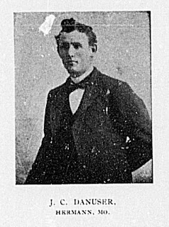
Jacob Christian Danuser, Land Surveyor
My interest in Jacob C. Danuser as a Missouri land surveyor originated with an article authored by Chris Wickern that appeared in Volume 7, Issue 3 of the American Surveyor Magazine (click here to go to the article). This article included a picture credited to Paul Dopuch, County Surveyor for Gasconade County, Missouri. In Volume 7, Issue 4 of the same magazine a reader made an inquiry about the picture and Paul Dopuch responded (click here to read the inquiry and response). In his response he mentioned J. C. Danuser as a former Gasconade County Surveyor who did very good work. Since I knew nothing about J. C. Danuser, I was interested to see what information I could find on this surveyor of high repute.
Following are some facts that I was able to discover about Jacob C. Danuser.


Jacob conveyed Lots 69, 71, 73 & 75 of Block 7 on West 18th Street in the City of Hermann to his daughter, Edna Steffen.
(Gasconade County Deed Book 97, page 514)
1961 August 08

1978 October 22
Jacob's daugther, Selma A. Danuser, died and was buried at Hermann City Cemetery.
(Latitude: N38°41'58.0" Longitude: W91°26'10.1" NAD 1983)


----------------------------------------------
Compilation of information by Steven E. Weible
Following are some facts that I was able to discover about Jacob C. Danuser.

1840 June 30
Jacob's father, Christian Danuser, was born in Switzerland.
 |
| Christian Danuser |
1846
Jacob's grandfather, Thomas Danuser, with wife, Barbara, and eight surviving children left native Switzerland and immigrated to the United States.
1846 April 28
Jacob's mother, Verena Christine Bottermann, was born in Hermann, Missouri.
 |
| Verena C. Bottermann Danuser |
1846 July 25
Jacob's grandfather, Thomas Danuser, acquired the Southeast Quarter of Section 8, T45N R04W of the Fifth Principal Meridian from David and Maria Louisa McKinney.
(Gasconade County Deed Book F, page 84)
1861 October 14
Jacob's father, Christian Danuser, enlisted at Hermann, Missouri, as a Private in Company E of the 4th Regiment of Missouri Volunteers.
1863 February 01
Jacob's father, Christian Danuser, was discharged from military service.
1864 May 05
Jacob's grandfather, Thomas Danuser, conveyed the Southeast Quarter of Section 8, T45N R04W of the Fifth Principal Meridian to Jacob's father, Christian Danuser.
(Gasconade County Deed Book P, page 362)
1864 May 27
Jacob's father, Christian Danuser, married Jacob's mother, Verena Christine Bottermann.
(Gasconade County Marriage License Book C, page 165)
1868 November 27
Jacob Christian Danuser was born at Little Berger, Gasconade County, Missouri.
1871 July 21
Jacob's grandfather, Thomas Danuser, died in Gasconade County, Missouri.
1881 October 21
Jacob's grandmother, Barbara Danuser, died at Hermann, Missouri.
1899 October 17
Jacob married Wilhelmina Johanna Carolina Wattenberg at Berger, Franklin County, Missouri.
(Gasconade County Marriage License Book 4, page 137)
1900 June 16
Jacob's occupation was listed as Baker on the 1900 Federal Census.
1900 August 03
Jacob and Wilhelmina's daughter, Selma A. Danuser, was born.
1900 November 06
Jacob was elected Gasconade County Surveyor and was commissioned by Missouri Governor Lon. V. Stephens.
(Gasconade County Deed Book 27, page 44)
1901 - 1908
Jacob served as Gasconade County Surveyor.
1903 March 25
Jacob and Wilhelmina's son, Erwin August Christian Danuser, was born.
1904 March 10
Jacob acquired Block 7 on West 18th Street of the Town of Hermann, Missouri, from William F. and Carrie Albert for $975.
(Gasconade County Deed Book 29, page 328)
1904 July 17
Jacob and Wilhelmina's son, Clarence C. Danuser, was born.
1906 November 07
Jacob and Wilhelmina's daughter, Edna Danuser, was born.
1909 - 1912
Jacob served as deputy to Gasconade County Surveyor Christian August Boesch.
1910 April 28
Jacob's occupation was listed as Gasconade County Highway Engineer on the 1910 Federal Census.
1920 January 20
Jacob's occupation was listed as Cashier at People’s Bank on the 1920 Federal Census.
1921 - 1932
Jacob served as Gasconade County Surveyor.
1922 March 18
Jacob's father, Christian Danuser, died at the Home for Disabled Volunteer Soldiers at Danville, Illinois, and was shipped to Hermann, Missouri, for burial.
1929 July 17
Jacob's mother, Verena Christine Danuser, died in Gasconade County, Missouri, and was buried at Hermann City Cemetery.
(Latitude: N38°41'56.2" Longitude: W91°26'08.3" NAD 1983)

1930 April 23
Jacob's occupation was listed as Gasconade County Surveyor on the 1930 Federal Census.
1932 December 19
Jacob and Wilhelmina's son, Erwin August Christian Danuser, died at Hermann, Missouri, and was buried at Hermann City Cemetery.
(Latitude: N38°41'58.0" Longitude: W91°26'10.1" NAD 1983)

1937 - 1940
Jacob served as Gasconade County Surveyor.
1937 December 20
Jacob's wife, Wilhelmina Johanna Carolina Danuser, died at Hermann, Missouri, and was buried at Hermann City Cemetery.
(Latitude: N38°41'58.0" Longitude: W91°26'10.1" NAD 1983)

1940 April 30
Jacob's occupation was listed as County Surveyor on the 1940 Federal Census.
1946 November 16
Jacob's brother, Fred William Danuser, died at Jefferson City, Missouri.
1947 March 01
Jacob and Wilhelmina's daughter, Edna Danuser, married Frank Steffen at Hermann, Missouri.
(Gasconade County Marriage License Book 11, page 413)
1954 November 13
Jacob's brother, Herman Thomas Danuser, died in Gasconade County, Missouri, and was buried at Hermann City Cemetery.
(Latitude: N38°41'55.4" Longitude: W91°26'06.4" NAD 1983)
1956 August 12
Jacob's brother, Christian Mathias Danuser, died at Washington, Missouri, and was buried at Hermann City Cemetery.
(Latitude: N38°41'55.5" Longitude: W91°26'07.8" NAD 1983)
1956 November 24
Jacob's sister, Louisa Caroline Danuser, died at Washington, Missouri, and was buried at Hermann City Cemetery.
(Latitude: N38°41'55.4" Longitude: W91°26'06.4" NAD 1983)
1959 September 25
Jacob conveyed Lots 57 & 59 of Block 7 on West 18th Street in the City of Hermann to his daughter, Selma A. Danuser.
(Gasconade County Deed Book 97, page 503)
Jacob conveyed Lots 61, 63, 65 & 67 of Block 7 on West 18th Street in the City of Hermann to his son, Clarence C. Danuser.
(Gasconade County Deed Book 97, page 504)
Jacob conveyed Lots 69, 71, 73 & 75 of Block 7 on West 18th Street in the City of Hermann to his daughter, Edna Steffen.
(Gasconade County Deed Book 97, page 514)
1961 August 08
Jacob died at Hermann, Missouri, at the age of 92 and was buried at Hermann City Cemetery.
(Latitude: N38°41'58.0" Longitude: W91°26'10.1" NAD 1983)
(Latitude: N38°41'58.0" Longitude: W91°26'10.1" NAD 1983)

1978 October 22
Jacob's daugther, Selma A. Danuser, died and was buried at Hermann City Cemetery.
(Latitude: N38°41'58.0" Longitude: W91°26'10.1" NAD 1983)

1990 July 03
Jacob's daugther, Edna Danuser Steffen, died.
1999 April 25
Jacob's son, Clarence C. Danuser, died and was buried at Hermann City Cemetery.
(Latitude: N38°41'55.4" Longitude: W91°26'05.7" NAD 1983)

Compilation of information by Steven E. Weible
Subscribe to:
Posts (Atom)