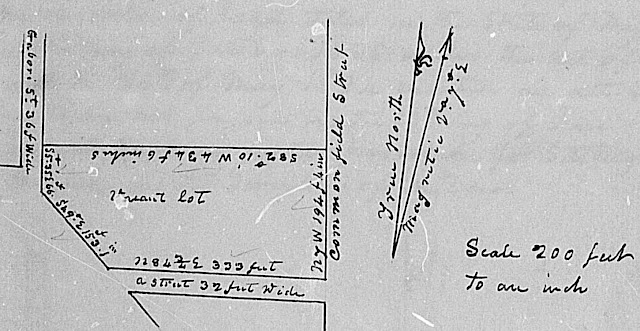
Plat and description of the Survey of a lot situated in block No. 5 of the town of Ste. Genevieve in township 38 north of the base line range 9 east of the 5th principal Meridian in the State of Missouri, surveyed on the 7th day of November in the year 1840 by Joseph C. Brown, deputy Surveyor, under instructions from the Surveyor of the public lands in the States of Illinois and Missouri, dated the 3rd day of September 1840. The said lot was not proven before the recorder of land titles in the State of Missouri but was surveyed as a vacant lot.
Description
Begin at a lime stone set at the eastern edge of Gabori Street, the SW corner of Jo. Bte. Pratte Senior's lot or the lot of his legal representatives, described on page 79 [303] of this book [survey number 149], thence S5°35'E along the eastern edge of Gabori Street 66 feet to a lime Stone set at a turn in said street; thence S49°E along the NE edge of said street 153 feet 1 inch Set a lime Stone at the Northern edge of a street 32 feet wide; thence N84 3/4°E along the northern edge of said street, the Southern boundary of the lot, 333 feet to a large cedar post, the South East corner of this lot and of block No. 5; thence N7°W along the western edge of Common field Street, the eastern boundary of this lot, 194 feet 4 inches to a lime Stone, the N.E. corner of this lot and S.E. corner of the lot of Jo. Bte. Pratte Senior's legal representatives at the western edge of Common field Street; thence S82°10'W along the S.E. boundary of the lot of said Pratte's legal representatives, the N.W. boundary of this lot, 434 feet 6 inches to the beginning.
(Brown's Surveys of Sainte Genevieve and New Bourbon, page 308, Missouri State Land Survey microfiche location: 724/0476A02)
Transcriber's note:
Gabori Street is now South Main Street
Common Field Street is now South Front Street
the unnamed street is now South Gabouri Street
-------------------------------
transcribed by Steven E. Weible
